

Toby Lloyd, Create Streets fellow, considers an option for intensification of inter war housing estates.
Finding a way to add new homes into low density suburbs has long been a holy grail of housing and planning policy. Lacking a decent model for suburban densification we are instead forced to fight ever more acrimonious planning battles over greenfield sprawl or ultra-dense point blocks on the few bits of urban land available for development. There really should be a better way of building more homes that adds to the richness of existing places without completely replacing the buildings or the people there already.
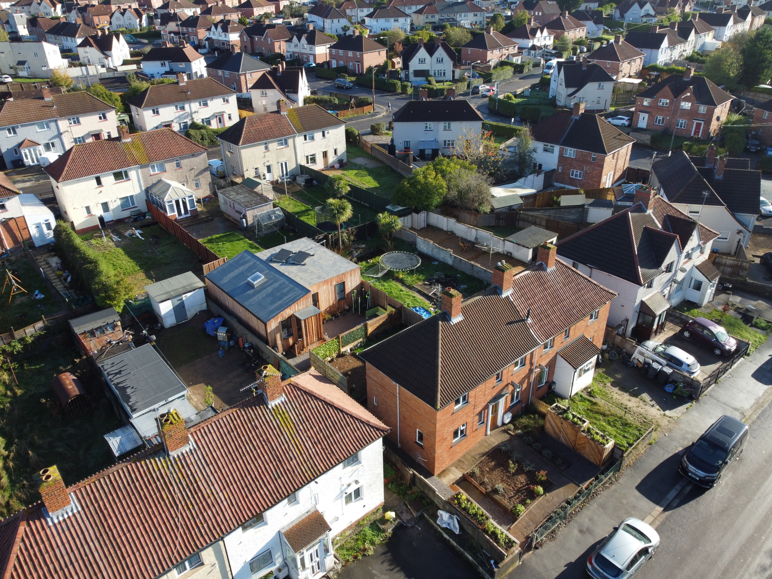
Create Streets have proposed one solution in the form of street votes, which is now on track to reach the statute books via the Levelling Up and Regeneration Bill. This is excellent news. But what if there was a way of adding new homes to existing neighbourhoods now, by working with the grain of existing policy and local communities’ priorities? This is what WeCanMake have pioneered in Knowle West. Their version of community-led urban infill has already delivered two rather nice new affordable homes in under-used spaces identified by local people themselves, to meet the housing needs of those same local people. And it does so without requiring expensive land acquisition, lengthy planning battles, or major new infrastructure. You can learn all about it here , but the key features are that local residents in mostly social housing come together to identify both their own community’s housing needs (such as places for young people to start a family, or for older parents to downsize into), and the spaces within the neighbourhood where these homes could go. They then get the social landlord (in Knowle West this is Bristol City Council) to transfer the sites to a community land trust which raises finance and organises the community to build the homes themselves.
What WeCanMake and the people of Knowle West have done is brilliant. But how replicable is this model? How many homes could other cities and communities build if they adopted the same approach? After all, the model will not work just anywhere. It’s been designed to suit Knowle West, a low density suburban neighbourhood in Bristol. So the question is: ‘how many places out there are similar to Knowle West?’ Happily, the answer is: ‘an awful lot.’ Fully 15% of the homes we have now – 3.3 million of them – were built between 1919 and 1939, and about a third of those were built by local councils.
During the 1920s, and particularly the 1930s, we built so many homes that by the start of the war one in three homes was less than twenty years old. Most of these were built in medium to large scale urban extensions of detached or semi-detached homes with gardens, set among wide roads and ample breathing space. Drawing on the ideas of the garden city movement, and enabled by the new mobility offered first by bicycles and trams, then by tubes and suburban trainlines, and later the motor car, these neighbourhoods were designed to free working people from the overcrowding and pollution of the nineteenth century inner city. This they undoubtedly did – but they also used up a lot more space, so that the footprint of most of England’s cities doubled between the wars, leaving a legacy of low density, car dependent neighbourhoods ripe for gentle intensification today.
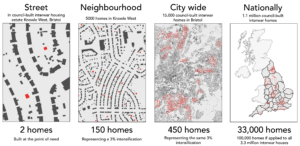
One way to gauge how much scope there is for the WeCanMake model is just to assume that the 1.1 million interwar council homes in England have Knowle West’s capacity to absorb new homes. WeCanMake have estimated that Knowle West can take a 3% increase in homes and population without new infrastructure, which suggests that similar neighbourhoods across England could fit an additional 110,000 or so homes.
This is a reasonable starting point – but it assumes that everywhere built between the wars is like Knowle West. Looking at the data in more detail we can compare both era of construction and residential density in every Lower Super Output Area in England to identify the neighbourhoods most physically similar to Knowle West. (LSOAs are the smallest geographic unit for which useful stats are available, with about 1,500 people each.)
Knowle West is made up of 11 LSOAs with 7320 homes in 360 hectares. These 11 areas range in density from 12 to 34 dwellings per hectare, and from 31 to 97% interwar construction. Using the middle of these ranges we can apply density thresholds of 20, 25 and 30 d/ha and % interwar construction thresholds of 50%, 60% and 70% to all 32,859 LSOAs in England (containing over 25 million homes), to give the following results.
| England LSOAs | >70% interwar | >60% interwar | >50% interwar |
| < 30 d/ha | 1,250 | 1,859 | 2,673 |
| < 25d/ha | 930 | 1,420 | 2,089 |
| < 20d/ha | 532 | 848 | 1,321 |
| England Homes | >70% interwar | >60% interwar | >50% interwar |
| < 30 d/ha | 766,200 | 1,166,520 | 1,715,270 |
| < 25d/ha | 569,190 | 889,940 | 1,338,210 |
| < 20d/ha | 326,670 | 533,730 | 847,260 |
Our central estimate is that there are 1,420 LSOAs in England in which more than 60% of the stock was built between the wars, and which have a density of less than 25 d/ha, containing 889,940 homes.
Assuming a similar potential spatial capacity as Knowle West of 150 possible sites per 5,000 existing homes suggests that these neighbourhoods might have under utilised space capable of fitting 266,982 additional homes of similar low rise typologies to the existing stock. Exactly how many of these sites could be developed, over how long, without straining the limits of local infrastructure, funding or political acceptability is another question – and one that requires locally-specific analysis to answer accurately. But if only 40% of these sites could be developed over say the next ten years it would produce 106,793 additional homes at effectively zero land cost, right where they are needed.
| England potential sites (150 per 5000 homes) | >70% interwar | >60% interwar | >50% interwar |
| < 30 d/ha | 229,860 | 349,956 | 514,581 |
| < 25d/ha | 170,757 | 266,982 | 401,463 |
| < 20d/ha | 98,001 | 160,119 | 254,178 |
| England development potential (40% of capacity) | >70% interwar | >60% interwar | >50% interwar |
| < 30 d/ha | 91,944 | 139,982 | 205,832 |
| < 25d/ha | 68,303 | 106,793 | 160,585 |
| < 20d/ha | 39,200 | 64,048 | 101,671 |
These figures are obviously just estimates, but they do at least indicate the potential of the WeCanMake community-led urban infill model, if it were applied to the huge swathes of the country built in the same period and to similar densities as Knowle West. Street votes have great potential to incentivise owner occupiers to come together to plan the sustainable densification of their own streets. Community-led urban infill offers a similar route for low density neighbourhoods dominated by social housing. Between them they could provide a really valuable additional source of new homes, built by and for local communities themselves.
Toby Lloyd is a Create Streets fellow
(with thanks to Neal Hudson and Ben Southwood for help and advice on sourcing data)